Customize Consent Preferences

We use cookies to help you navigate efficiently and perform certain functions. You will find detailed information about all cookies under each consent category below.

The cookies that are categorized as "Necessary" are stored on your browser as they are essential for enabling the basic functionalities of the site. ... 

Always Active

Necessary cookies are required to enable the basic features of this site, such as providing secure log-in or adjusting your consent preferences. These cookies do not store any personally identifiable data.

No cookies to display.

Functional cookies help perform certain functionalities like sharing the content of the website on social media platforms, collecting feedback, and other third-party features.

No cookies to display.

Analytical cookies are used to understand how visitors interact with the website. These cookies help provide information on metrics such as the number of visitors, bounce rate, traffic source, etc.

No cookies to display.

Performance cookies are used to understand and analyze the key performance indexes of the website which helps in delivering a better user experience for the visitors.

No cookies to display.

Advertisement cookies are used to provide visitors with customized advertisements based on the pages you visited previously and to analyze the effectiveness of the ad campaigns.

No cookies to display.

admin
Pinned July 13, 2016

<> Embed

@  Email

Report

Uploaded by user
Google brings higher-resolution imagery to Earth and Maps
<> Embed @  Email Report

Google brings higher-resolution imagery to Earth and Maps

Edgar Alvarez , @abcdedgar  June 27, 2016


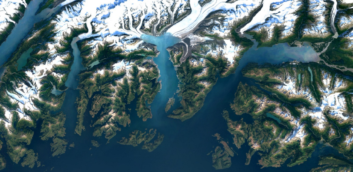
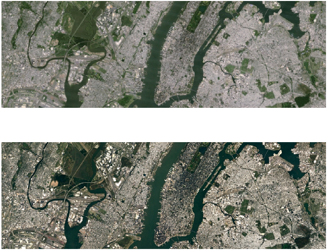
Every few months or so, Google improves the satellite imagery on services like Earth and Maps. Now, as part of its efforts to keep making the experience better for users, the search giant is going to offer higher-resolution virtual views going forward. You’ll now notice sharper imagery of areas around the world, thanks to the latest data from the Landsat 8 satellite and “new processing techniques” that Google’s implementing.

Based on one of the examples from the company (pictured below), you’re able to tell the difference right away. Everything is less blurry from afar. You can see more places for yourself on Google Earth, or by checking out the satellite option on Google Maps.

A satellite image of New York City on Google Earth. Before (above) and after (below) the update.

Source: Google
 
Edgar began hitting newsrooms at a young age, when his dad worked at a newspaper back in the 90s. Growing up, he had two passions: technology and football (soccer). If he wasn’t on the pitch scoring hat-tricks, he could be found near his SNES or around the house taking things apart. Edgar’s also deeply in love with tacos, Jordan sneakers and FIFA, in no particular order. He lives in New York City with his better half.

(38)