Google has retooled its search and maps with vital wildfire information
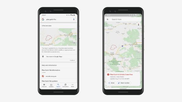
As wildfires rage in California, and Colorado reports the second largest wildfire in that state’s history, Google has announced it will be providing near-real-time information about such conflagrations on its search engine and mapping platform.
In addition to breaking news from media sources, information from local government offices, and safety tips from the Red Cross, Google will provide updated maps of the extent of fires, based on satellite data from the National Oceanic and Atmospheric Administration, and information about road closures and alternate routes. In a videoconference demonstration, Google product manager for crisis response Can Comertoglu showed how Google Maps provided directions from Glenwood Springs to Avon, Colorado, routing around a usual short route along Interstate 70, with a note that the route was affected by the ongoing fires in the area.

The company did a pilot test of the program last year around roughly five wildfires, working with agencies such as California Governor’s Office of Emergency Services and the Office of Emergency Management in Boulder, Colorado, to make sure they could provide information accurate and timely enough to be useful.
“This information is potentially life and death when we’re talking about fast-moving disasters like fires,” says Ryan Galleher, program manager for crisis response at Google.
Updates to Google’s driving directions can help people get to safety if familiar roads are closed.
In Boulder County, where significant wildfires have been an issue every month of the year except for January, there is a reverse-911 style service to notify residents via phone call about emergencies such as fires. But the service is opt-in, and especially with the decline of landlines, not all residents are signed up. Having the information available through Google provides another way for people to get real-time data about disasters that can rapidly erupt, says Justin Bukartek, the deputy director of the Boulder Office of Emergency Management, a joint city and county agency.
“Speed is the name of the game out here,” he tells Fast Company. “This is just a force multiplier for us as far as notifying our residents.”
And the updates to Google’s driving directions can help people get to safety if familiar roads are closed or they become turned around during a fire, Bukartek says.
The new features came after the company has found that during disasters, people turn to online resources they already use, such as Google Maps and Search, says Google crisis response product partnerships lead Ruha Devanesan. The company first began providing crisis information during a forest fire on Mount Carmel in Israel about a decade ago, after workers at the company office in Haifa were surprised they couldn’t find more real-time information about the disaster that they could see signs of from their own office.
Since then, Google has launched what it calls SOS alerts, which provide contextual information when people search for data about an unfolding disaster or emergency. They’ve been used for more than 250 crises, from fires to storms, and for the initial phase of information around the COVID-19 pandemic, Devanesan says. One of the company’s ongoing goals has been to provide more detailed geographical visualizations and maps around ongoing emergencies, and it’s made other efforts like working with NOAA and similar agencies around the world to highlight hurricane forecast cones and with the U.S. Geological Survey to bring in detailed earthquake information.

For the new wildfires, data about spread comes from NOAA’s Geostationary Operational Environmental Satellite Program. The agency runs its own algorithms to locate hot spots—”NOAA provides imagery that basically says, we think the pixels in this image are on fire right now,” Galleher says—and that public data is then processed by Google using the Google Earth Engine to map the borders of wildfires and provide that information in search and map results.
The company also works with agencies like local departments of transportation to make sure that traffic reroute information makes sense as well.
Of course, since internet access isn’t universally available, especially as fires or other disasters damage power lines, communication networks, and cell towers, Google can’t necessarily reach everyone in areas affected by fires. To that end, Boulder’s Bukartek says people can still get information through other sources, including radio broadcasts and, in some cases, even personal notifications, especially in mountainous areas of the county where connectivity is limited.
“We’re actually reliant on our mountain deputies to do a lot of door knocking and door evacuations,” he says.
(6)


