Throughout time, mapping the Earth hasn’t simply been an effort to accurately model the planet, but to define reality. Behind the great cartographers have stood monarchs, republics, emperors, sultanates, and even corporations like the Dutch East Indies Company. A range of entities have dictated maps’ purposes, edited their features, and created political boundaries.
Adam Lowe and Jerry Brotton of Factum Arte, an art and technology collective, take quite a different tack to map-making. In their ongoing cartographic art project Terra Forming: Engineering the Sublime, Factum Arte creates 3-D relief models of five maps of Earth and flood them. Designed to provoke discussions about climate change, human (or animal) migration, and other pressing issues, Terra Forming grew out of an exhibition Lowe and Brotton curated for the Fondazione Giorgio Cini’s exhibition on the island of San Giorgio Maggiore. (The Fondazione Giorgio Cini, located in Venice, Italy, is a center that conducts climate change research.)
While on San Giorgio Maggiore, Brotton and Lowe noticed how parts of the island were reclaimed from the lagoon in the second half of the 20th century. After talking about their long-term shared interest in cartography and maps, the two hit upon the idea of making a topographic and bathymetric (underwater depth) relief map of the Earth without water—a map the size of a soccer field.
“It grew from there to a desire to create a spectacle that visually re-staged an epic flood,” Lowe explained. “When we built a model, the result was dramatic—at a certain point the world suddenly became recognizable, and it seemed to have the same effect on everyone. It draws you in, makes you think, surprises, and reassures. The result is that you think about change and the dynamic fragility of the earth.”
A conceptual animation showcases Factum Arte’s plans for a giant 3-D flood installation on San Giorgio Maggiore. The video begins with a flyover of Venice before descending to the island’s soccer field, where Brotton and Lowe’s relief map would be located. The virtual camera then does an aerial sweep over the 3-D map before showing the proposed flooding from on high.
“It’s a reappearing act,” Lowe explained. “Of course it’s impossible—there is not enough water on or in the planet for this to happen. But it is a poetic act focusing on change.”

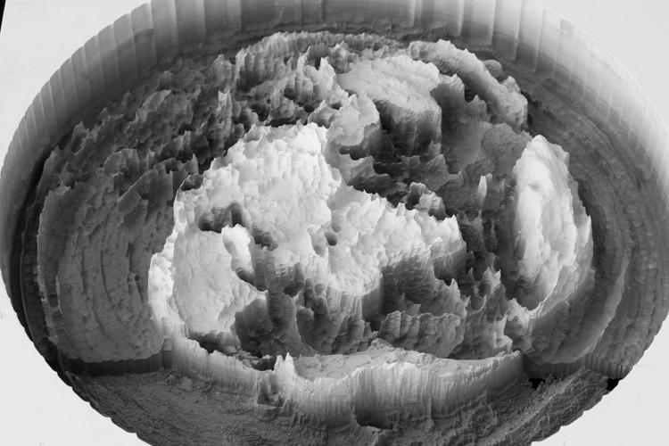
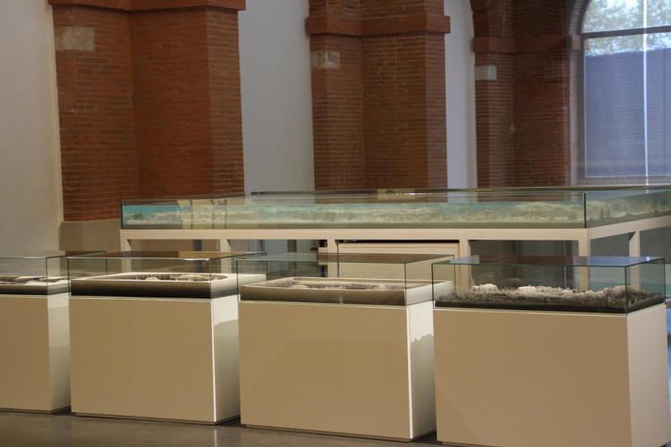
Factum Arte has also made an animation of a waterless 3-D globe, along with their five 3-D relief models based on historical maps. The first, known as the “Azimuthal Projection,” evokes the Mappa Mundi, which places Jerusalem at its center and the east at the top. The Cordiform (or “Heart-Shaped”) Projection is significant because America appears for the first time on a global map; while the equi-rectangular Mercator Projection distorts and enlarges the size of objects as the latitude rises from the Equator to the pole.
Factum Arte also uses Buckminster Fuller’s Dymaxion Projection, which maps the Earth onto an icosahedron (20-sided polyhedron) that is unfolded and flattened, and the Land-centric projection, the equi-rectangular map most familiar to the masses. It’s also working with some other projections, one of which will be a map with the south located on top. (This 3-D relief might well be Muhammed Al-Idrisi’s famed Tabula Rogeriana map.)
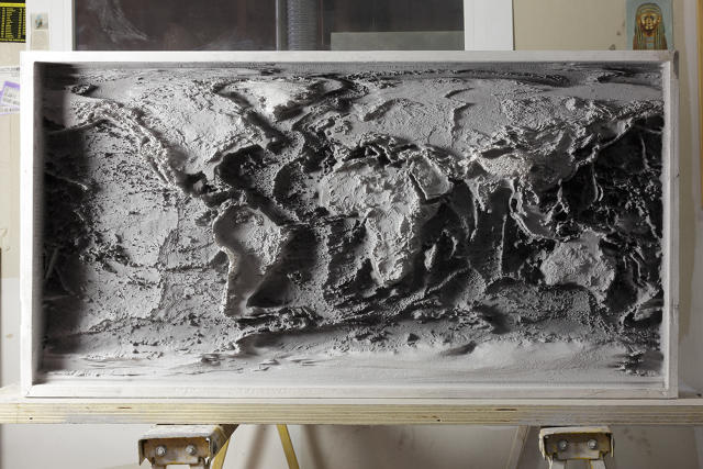
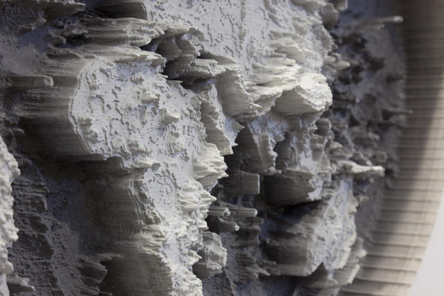
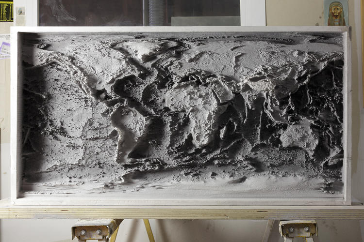
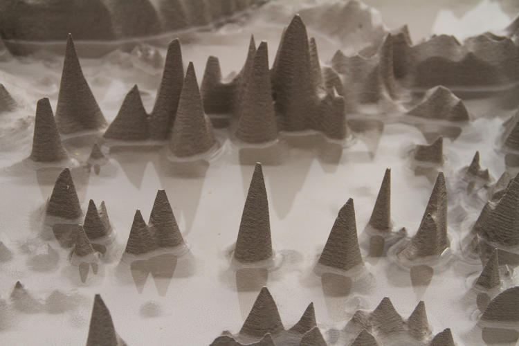
To create the 3-D reliefs of these five projections, Brotton and Lowe gathered high-resolution topographic and bathymetric data from the public domain. They then created each projection by using a CNC machine to carve gradated blocks of plaster, each approximately 50 by 100 centimeters. In the process they exaggerated the Z axis (depth), multiplying by a factor of 100. If they hadn’t done this, the viewer wouldn’t see anything significant for their imagined flood, which Lowe said must contain “moments of surprise and drama”.
As with the conceptual animation, Brotton and Lowe initially present the smaller scale 3-D reliefs of Earth’s surface devoid of water, then fill them with water until they reach current sea levels. The models are then flooded until a “drowned world” is fashioned. This is not only designed to reckon with the ecological impact of climate change, but to provoke thoughts of the many other types of change traditionally left off maps—the spread of viruses, for instance.
“Terra Forming is not intended as a scientific fact but as an artistic act full of the potential to trigger debate and thought,” says Lowe. “It is inspired by change, and by the idea that it could provide a physical backdrop onto which we can project important cartographic things that are normally left off maps because they change—weather maps, the clouds, wind speeds, salinity in the ocean, the movement of radioactive material, ocean temperatures, political boundaries, bird migration, human migration, the spread of disease, the growth of algae, airplane flight paths and frequency, invisible forces, and many more things.”

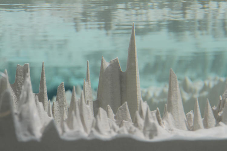
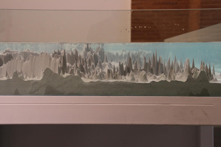
In Terra Forming, Brotton and Lowe also try to subvert the Terra-centric projection by emphasizing water over land. For the 2014 Anthropocene Monument exhibition at Les Abattoirs in Toulouse, France, Lowe and Gregoire Dupond used a CNC routing machine to carve the Terra-centric map into a 2 x 4 meter block of polyurethane. They then placed this 3D relief into a glass tank with an aquarium pump and reservoir of water. Periodically throughout the day, they flooded the projection until every last mountain peak was submerged.
“It’s slow and rather beautiful,” Lowe said. “The surface tension of the water is a problem, but it feels like a wall of water assaulting the land—a metaphorical tsunami, and it suddenly breaks and the water flows fast.”
“The map is is a form of realistic representation—more real than a photograph, which is one aspect of visual reality fixed from one point of view, if the metaphor is based on a camera-based photographic image,” Lowe added. “Each block took weeks on the milling machine [because] we wanted a cartographic project that pushed manual craft skills and was in communication with James Wyld and Elisée Reclus, some of the most ambitious and imaginative cartographic thinkers.”
One Earth, Many Maps
Apart from Wyld and Reclus’s work, Lowe and Britton found Buckminster Fuller’s Dymaxion Projection particularly appealing because he gave up on the rectangular model, but kept Africa looking “familiar.” In the Dymaxion Projection there is no right way up. And when compared to the Mercator map there is much less distortion in the relative size of areas and shapes.
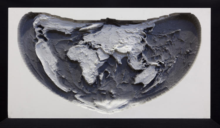
In the Terra-centric Projection, north is no longer at the top of the world. Before being projected onto a rectangle, the globe was rotated, stretching areas of water to infinity at the top and bottom rather than along the two polar ice caps. Interestingly, as Lowe and Britton explain, “a few islands are sacrificed and are now unrecognizable”. It almost sounds like some fictional map imagined by the Argentine writer Jorge Luis Borges, a lover of maps, infinity and labyrinths.
“We think only Tristran de Cuna [a remote volcanic archipelago in the Atlantic Ocean] is really stretched beyond reason,” Lowe said. “I like to think Borges would love it. On San Giorgio Maggiore it will sit beside the Borges Maze—commissioned by Pasquale Gagliardi, designed by Randell Coates, arranged by Pedro Memmelsdorf, and opened by Borges’ widow.”
Though Factum Arte has exhibited parts of Terra Forming, and produced videos to demonstrate their artistry, Lowe said that project—like many ambitious cartographic models—is still an idea for a much larger spectacle. Lowe and Brotton are currently focusing their efforts on the San Giorgio Maggiore soccer field because they work closely with Fondazione Giorgio Cini.
“It is in the heart of Venice threatened by a sinking land mass and rising sea level, but it could be anywhere,” said Lowe. “The Gulf, London, somewhere in China, somewhere cold, somewhere hot. It needs to be physical and it needs to be big (25 x 50 meters is ideal).”
At this scale, Lowe believes Terra Forming would begin to address what he calls the “folly of large scale geo-engineering and climatic interventions”. Lowe, quoting philosopher Simon Schaffer, believes that “the decision to take charge and act” on issues like climate change and overpopulation “is constantly frustrated because of a massive failure of vision, of aesthetics”.
Factum Arte hopes that Terra Forming can help overcome that failure of imagination with its own particular brand of aesthetics and vision—a spectacle to rival Wyld’s Great Globe, a 19th century cartographic model of the Earth projected on the globe’s interior. Lowe said that this future exhibition may project dynamic maps onto the flat reflective water, which would include data such as temperature, gulf streams, radioactivity, salinity, political boundaries, light pollution, and other phenomena.
“We are hopeful that this can become a reality,” Lowe said. “It just needs some vision and some money.”

Fast Company , Read Full Story
(98)