These photos of the U.S.-Mexico border show that reality is very different from the rhetoric
In early 2017, in the wake of Trump’s inauguration, photographer Elliot Ross and writer Genevieve Allison decided to drive the entire length of the 2,000-mile U.S.-Mexico border–a trip that took four months and 10,000 miles of driving as they moved back and forth between access points. “We did our best to see every inch of the actual physical border,” says Ross.
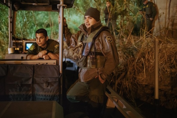
Their goal was to find out how much truth–if any–lay in the narrative that Trump was spreading about the border. “We really wanted to see where the reality existed on that spectrum from the people we spoke to while transiting the entire border to get the largest demographic possible,” he says. “And to see where the lived experiences of the people that we spoke with compared and contrasted with the president’s message.”
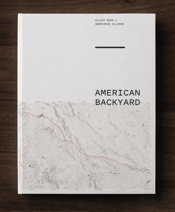
A new book called American Backyard documents the journey. In McAllen, Texas, in the Rio Grande Valley–one of the fastest-growing areas in the country, with a largely Hispanic population and a far lower crime rate than the average American city–they saw luxury stores where wealthy Mexicans cross the border to buy American goods, and spoke to Mexican-born Americans who cross the border in the other direction to get deals. A block from the border fence, they met a teenage girl who had recently had her quinceañera. In Edinburgh, Texas, they rode along with border patrol agents and saw river patrol boats equipped with machine guns. In West Texas, they watched a 15-year-old Honduran boy walk across the border over an old railway bridge; they gave him some water and he politely asked how to find immigration officials. (They helped, and then watched as he was taken away in a patrol car.) In Arizona, they met a volunteer who builds permitted water stations for people making the dangerous journey through the Sonoran Desert, and a forensic anthropologist whose job is to identify the remains of the hundreds of people who don’t make it. At the Border Field State Park in California, where the border wall leads into the Pacific Ocean, they saw family members talk to each other across the heavily surveilled fence in the “International Friendship Park.”
[Photo: Elliot Ross]
Throughout the trip, they tried to find support for the expansion of the border wall, intending to present opposing perspectives in the book. But that support didn’t exist. “In terms of people who live within a 15-minute, 30-minute drive to the border, and understand that the reality that comes along with that, no, there’s no support for building the wall,” says Ross. In Bisbee, Arizona, a Trump-supporting Republican rancher whose land abuts the border said that he thought the wall was a waste of money in remote areas. Many conservative ranchers dislike the idea of the wall on their land both for political reasons (“government coming in to use eminent domain to seize part of their land for border easement is the definition of federal overreach,” Ross says) and because the construction and other patrol activity can block cattle from accessing water. In Nogales, the border wall caused catastrophic flooding when it was built.
Most Americans, Ross and Allison say, don’t have a full understanding of what the border is like. “From the imagery that’s available through the media and online, there was kind of a limited representation of what the border looked like, and what narratives were presented,” says Allison. The book hopes to help present a more nuanced view.
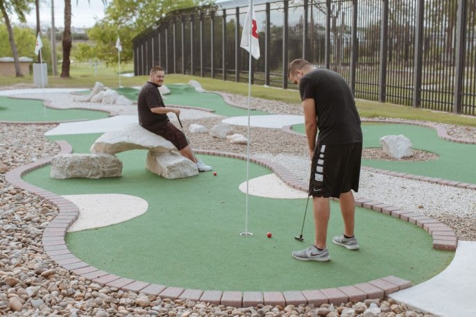
The border fence bounds the community golf course in Eagle Pass, Texas.
[Photo: Elliot Ross]
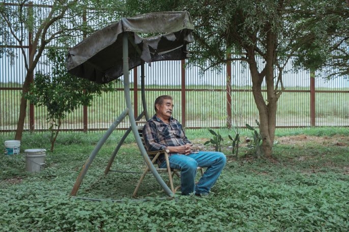
George Tolentino, Brownsville, TX. “I’ve been in this house since 1975 – it was one of the first homes (in this area) and surrounded by farmland. Health-wise, it’s not that great because of all the dust the CBP agents create (due to the patrol trucks driving back and forth through his backyard with drags). I can’t sit outside and enjoy a BBQ anymore. Some of my neighbors have breathing problems(…) people need to get together, but everyone is waiting for someone else to do it.” – George Tolentino, 64, retired truck driver, Brownsville, Texas.
[Photo: Elliot Ross]
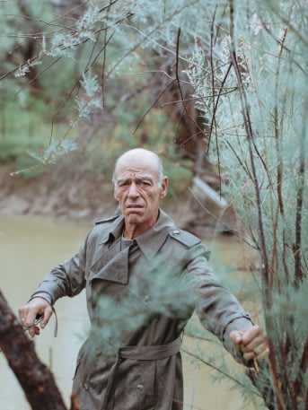
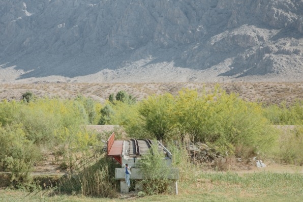
Bill Addington, South of Sierra Blanca, TX. Bill Addington, a lifelong environmental and social activist on his family land south of Sierra Blanca, Texas. He stands, holding the wire supports of his privately owned and highly controversial footbridge that spans the Rio Grande that Customs and Border Patrol has ordered him to remove on a number of occasions.
[Photo: Elliot Ross]
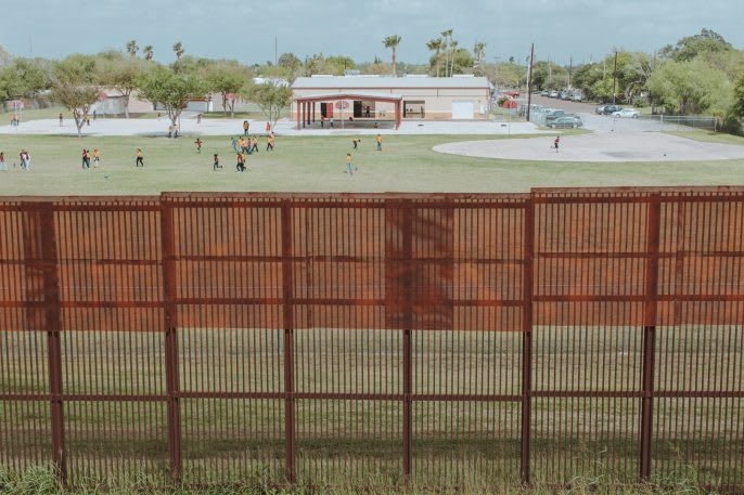
Garden Park Elementary, Brownsville, TX. A border fence bounds recess at Garden Park Elementary in Brownsville, where, according to gym teacher Arnurfo Castille, 20 to 30 of the school’s students legally come across the bridge from Mexico every day. After a 1982 Supreme Court ruling, undocumented children in the U.S. also have the same right to attend public schools in Texas as U.S. citizens.
[Photo: Elliot Ross]
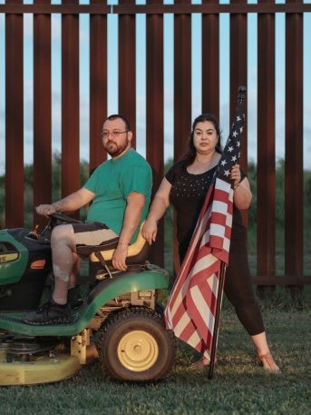
Solis Home, South Point, TX. “I don’t have a backyard, I have a border fence,” Melissa Solis says. When construction of the fence started on their land that has been in the Solis family for generations, “All my mom did was cry. (…) You know, you come to realize in the United States, you can’t really be free, it’s just like any other country,” Melissa, a school administrator, adds. According to the Cato Institute, the United States ranks 20th on the Human Freedom Index.
[Photo: Elliot Ross]
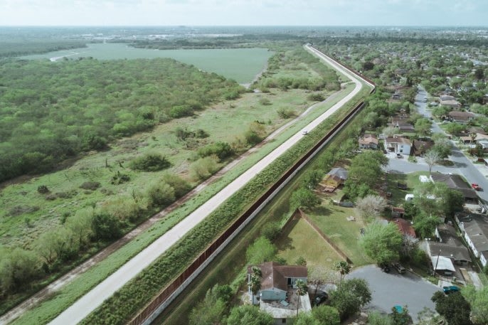
Border Fence and Levee, Brownsville, TX. A corridor made of concrete, steel and 24 hour surveillance separates Brownsville’s Milpa Verde neighborhood on the right from a fragment of subtropical riparian woodland on the left. “Everything, everything, we fight for has its genesis in the disconnect between people and the environment,” explains Stefanie Herweck, environmental activist and lecturer at University of Texas Rio Grande Valley. “We don’t have the freak’n redwoods but this is our nature. If people can’t see it, they don’t see the point in protecting and preserving it.”
[Photo: Elliot Ross]
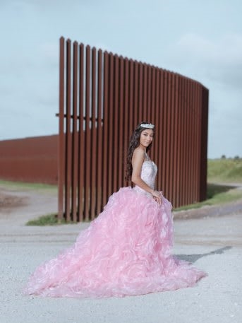
Jaymin Martinez, Brownsville, TX. Jaymin Martinez lives with her mother, father, and younger brother just two blocks away from the border fence. Born just a week before 9/11, she doesn’t remember a time without “WMD’s” or our extended wars in the the Middle East and can barely recall the construction of the first segments of The Wall. It’s a part of daily life, and its presence has largely faded into the background for her. Having turned 15 recently, her Quincean~era is fresh on her mind. When we first met, Jaymin (pronounced “Jay-meen”) she proudly showed us home videos, the elaborate rose gown she wore, and explained the traditions surrounding this right of passage for so many young Latin American women. Despite the economic hardships that the Martinez family has faced in recent years in recovering from a devastating flood, four car accidents and health problems, all on a single income, and the enormous cost of having a Quincean~era, it was important to Jaymin and her family to continue this important Tejano tradition.
[Photo: Elliot Ross]
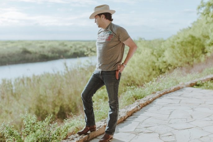
Rep. Alfonso “Poncho” Neva´rez, Eagle Pass, TX. Rep. Alfonso “Poncho” Neva´rez, 44, Texas State Representative for District 74, a constituency that spans 45,000 square miles, 12 counties and two time zones. “People ask what’s the remedy? I say ‘well, we’re not sick. Long before we became this flashpoint for political careers to live and die by, we’ve been here, living and dying by this river.’”
[Photo: Elliot Ross]
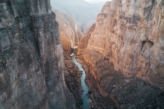
Mariscal Canyon, Big Bend National Park. Big Bend National Park, where the 1,800-foot vertical barrier of Mariscal Canyon separates Mexico on the right from Texas on the left, is said to be one of the first places President Trump will begin building a 30-foot border wall. 95 percent of the land bordering the Rio Grande in Texas is privately owned. With land available to him from Big Bend National Park, Big Bend State Park, and Black Gap Wildlife Management Areas, Trump may make good on his campaign promise by beginning construction on a border wall in these protected lands first.
[Photo: Elliot Ross]
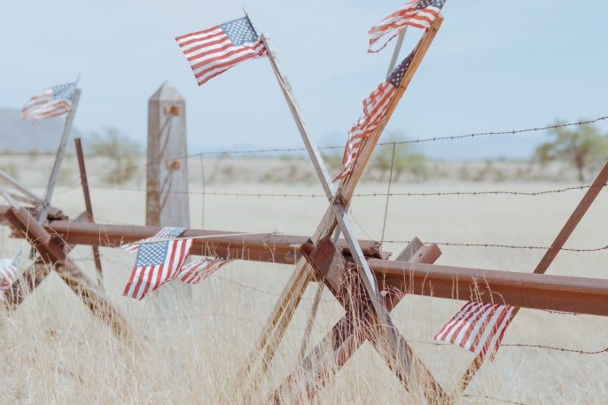
Flags punctuate a “Normandy” style border fence in Arizona where CBP agent Brian Terry was shot and killed by Mexican drug smugglers in 2010.
[Photo: Elliot Ross]
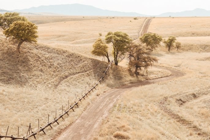
A tree is bifurcated by the border fence near Lochiel, Arizona.
[Photo: Elliot Ross]
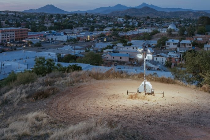
A neighborhood under tight surveillance and immediate proximity of an 18 foot high bollard style fence in Nogales, Arizona.
[Photo: Elliot Ross]
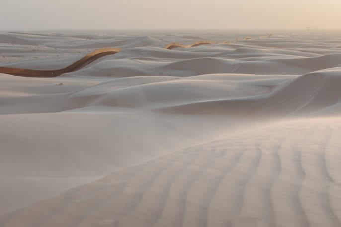
Sand Dragon, Algodones Dunes, California. Nicknamed by the border patrol agents as “The Sand Dragon,” this seven mile, 40 million dollar section of floating wall is designed to shift above the ever moving sand dunes.
[Photo: Elliot Ross]
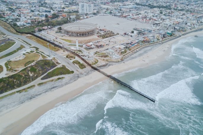
After almost exactly 2,000 miles, the border meets the Pacific Ocean with the steel bollard fence plunging a few hundred feet out to sea.
[Photo: Elliot Ross]
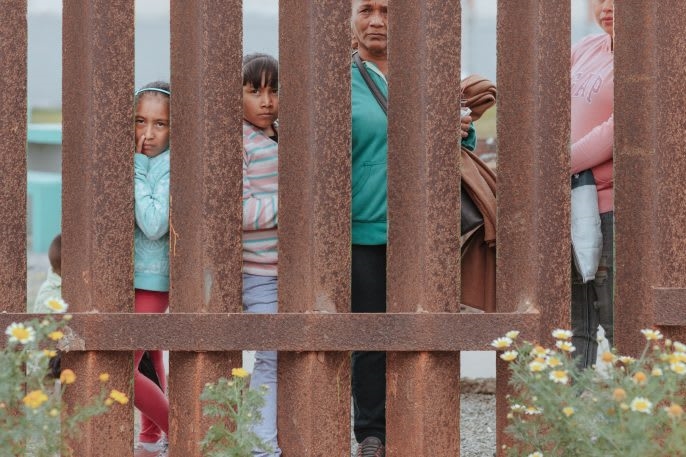
A mother along with her daughter and grandchildren sees her son for the first time in twenty-two years at Friendship Park in San Diego.
[Photo: Elliot Ross]
(16)

