This interactive map shows the key places that must be protected to curb climate change
The world’s population has tripled since 1950, and the number of megacities has grown from one—New York City—to more than 30, from Mexico City to Shenzhen to Hyderabad. But roughly half of the land on the planet is still in a natural or semi-natural state. A new map shows exactly where that land is, and why it’s critical to protect.
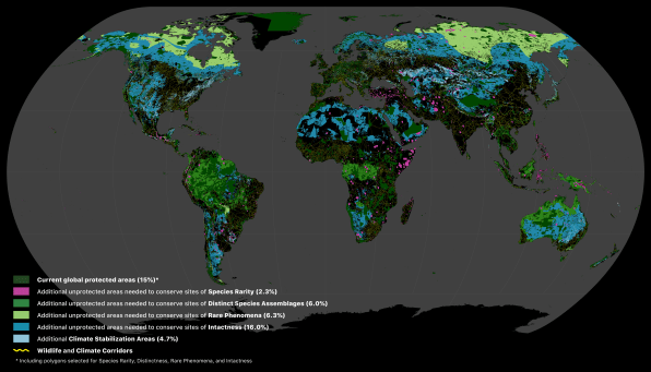
The project, called the Global Safety Net, maps out both areas that are already protected, such as national parks, and those that need to be protected to tackle simultaneous crises: climate change and the loss of biodiversity.
Scientists spent two years developing the map. In the 2016 book Half-Earth, the biologist E.O. Wilson had proposed protecting half the planet’s surface. “We were asking, well, is there even 50% left?” says Karl Burkart, the managing director of the nonprofit One Earth, which helped fund the analysis. Wilson, who wasn’t involved with the study, suggested that all protected areas should be free of humans. That much completely untouched space isn’t left. But when indigenous lands are included, the total space adds up to 50.4%.

The project, which can be explored online using Google Earth Engine, maps out areas that are critical for rare species to survive, high biodiversity areas, and regions that large animals visit seasonally. It also maps out areas of wilderness that may not be the highest priority for biodiversity but are still intact examples of different ecosystems, along with areas that can play an important role in sequestering carbon. The map also includes potential wildlife corridors that animals could use to migrate between natural areas.

As countries make pledges to protect nature, they can use the maps to make conservation plans. Right now, most governments “don’t have very sophisticated data products to inform the decisions they’re going to have to be making,” says Burkart. Zones that rare species need to survive, shown as pockets of pink on the map, should be the first priority.
Protecting wild areas for biodiversity can also help prevent future pandemics; as habitat is lost, it forces animals in closer contact with humans, spreading disease. Some experts suggest that Brazil, where swaths of Amazonian rainforest are being lost now, could be the place where the next pandemic emerges.
Nearly all of the areas highlighted on the map will also need to stay intact to prevent the worst impacts of climate change. “It’s very limited how much land can still be converted or how much forest could be lost before we totally lose the window to achieve the 1.5 degree Celsius target,” he says. “If we lose much more of that, we’re in uncharted territory. The world is at 1.1 now. And you can see what’s already happening with fires in California and Australia.”
Fast Company , Read Full Story
(42)


